
Вдоль узкой полоски пустыни, на западном берегу Нила, выстроилась цепочка величественных пирамид, являющихся визитной карточкой Египта. Почему именно здесь, вдали от современного русла реки, древние египтяне решили воздвигнуть свои монументальные творения? Долгое время ответ на этот вопрос оставался загадкой, окутанной песками времени. Но благодаря современному подходу, объединившему данные радарной съемки, геофизических исследований и анализа почвы, завеса тайны наконец приподнялась.
Ученые обнаружили следы крупного древнего рукава Нила, названного «Ахмарат», что в переводе с арабского означает «река пирамид». Невидимый на оптических снимках, этот палеоканал, скрытый под слоем песка и плодородными полями, был детально реконструирован с помощью радарных данных и топографического анализа.
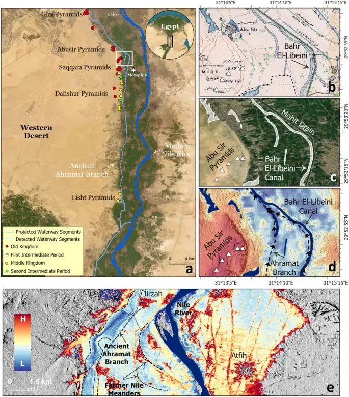
Протяженностью около 64 км и шириной от 200 до 700 метров, Ахмарат протекал у подножия Ливийского плато, вдоль которого и располагается большинство пирамид. Результаты исследования показали, что этот рукав был активен в период Древнего и Среднего царств, во времена, когда возводились величественные усыпальницы фараонов.
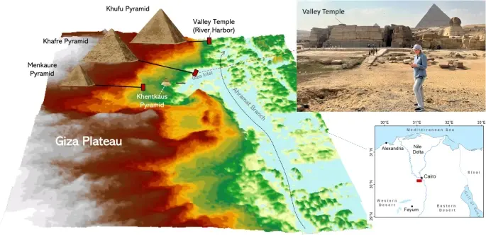
Многие пирамиды, датируемые этими эпохами, имеют дороги, ведущие к Ахмарату. Эти дороги заканчиваются погребальными храмами, которые, как предполагают исследователи, служили речными портами, оживленными точками на водной артерии древнего Египта.
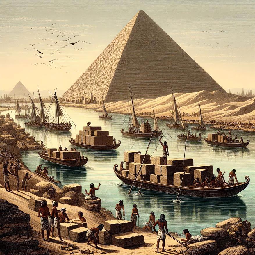
Открытие Ахмарата не только проливает свет на выбор места для строительства пирамид, но и раскрывает секреты их возведения. Ученые предполагают, что река использовалась для транспортировки рабочих и строительных материалов.
Анализ высоты пирамид и их удаленности от современной поймы Нила позволил реконструировать изменения уровня воды в Ахмарате на протяжении нескольких династий. В начале Древнего царства, особенно во времена IV династии, уровень воды был высоким, о чем свидетельствует удаленность пирамид, таких как Ломаная и Розовая, от поймы. В период V династии уровень воды значительно понизился, о чем говорит расположение пирамид вблизи современной поймы. К концу V династии и в период VI династии уровень воды вновь повысился, что подтверждается расположением пирамид Пиопи II и Меренра, находящихся в глубине пустыни.
Помимо основного русла, радарные данные выявили сеть более мелких, но не менее важных рукавов, соединявшихся с Ахмаратом. Эти рукава, ныне погребенные под песком, образовывали своего рода заливы, где вода была достаточно спокойной для швартовки судов.
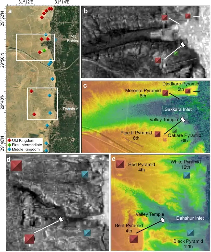
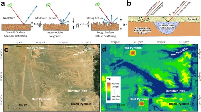
Одним из таких заливов был Дахшурский, к которому вела дорога Ломаной пирамиды — первой пирамиды фараона Снофру, возведенной в IV династии. Эта пирамида, расположенная в глубине пустыни, долгое время ставила ученых в тупик: почему погребальный храм, который обычно располагался у воды, был построен так далеко от Нила? Теперь ответ найден — храм выходил на берег Дахшурского залива, являвшегося частью водной системы Ахмарат.
Другим важным рукавом был Саккарский залив, к которому вели дороги пирамид Пиопи II и Меренра (VI династия). К берегам Гизского залива, также соединенного с Ахмаратом, вели дороги пирамид Хефрена, Микерина и Хенткаус. Пирамида Хуфу, самая крупная в Египте, по-видимому, была напрямую связана с основным руслом Ахмарата.
Исчезновение Ахмарата ученые связывают с тектонической активностью, вызвавшей наклон дельты Нила в северо-восточном направлении. Из-за этого река постепенно смещалась на восток, в сторону более низкой поймы. Дополнительным фактором, способствовавшем обмелению Ахмарата, стало увеличение количества песка, переносимого ветром из Западной пустыни, особенно в период засухи, предшествовавшей Среднему царству. Снижение уровня воды в реке, вызванное засухой и уменьшением количества осадков, привело к постепенному обмелению и исчезновению Ахмарата.
Открытие реки Ахмарат — это не просто научное достижение, это ключ к пониманию повседневной жизни и истории Древнего Египта. Река, некогда бывшая водной артерией этой могущественной цивилизации, помогает нам увидеть, как ландшафт влиял на развитие человеческой деятельности в этом легендарном регионе.
Используя комплексный подход, объединяющий данные радарной съемки, геофизические исследования и анализ почвы, ученые смогли реконструировать древний ландшафт и пролить свет на загадки прошлого. Этот метод может быть использован для поиска других погребенных речных систем в засушливых регионах по всему миру, открывая новые страницы истории человечества.
Если река Ахмарат была настолько важна для строительства пирамид, почему её следы не были обнаружены раньше?
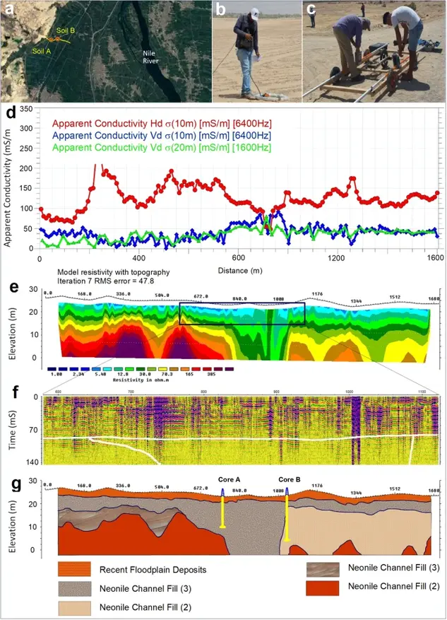
Долгое время археологи фокусировались на поисках следов древнего Нила в непосредственной близости от пирамид, не предполагая, что река могла сместиться на значительное расстояние. Кроме того, река Ахмарат была скрыта под толщей песка и плодородных полей, что затрудняло её обнаружение традиционными методами. Только благодаря современным технологиям, таким как радарная съёмка и геофизические исследования, удалось «увидеть» сквозь толщу земли и реконструировать древнюю водную артерию.
Как изменилось бы наше представление о строительстве пирамид, если бы река Ахмарат не была обнаружена?
Отсутствие реки Ахмарат оставило бы открытым вопрос о том, как древние египтяне транспортировали многотонные блоки камня и другие строительные материалы к месту строительства пирамид. Гипотезы о сухопутной транспортировке с использованием огромного количества человеческих ресурсов выглядели бы менее убедительными, что породило бы новые споры и, возможно, даже возродило бы некоторые фантастические теории о строительстве пирамид.
Могут ли быть найдены другие, ещё более древние реки, связанные с ранними этапами развития египетской цивилизации?
Вероятность обнаружения других палеорек, сыгравших важную роль в истории Египта, достаточно высока. Климатические изменения и тектоническая активность на протяжении тысячелетий неоднократно меняли ландшафт долины Нила. Поэтому комплексные исследования с применением современных технологий могут привести к новым открытиям, которые ещё больше расширят наши знания о Древнем Египте.