
31 августа 1886 года. Поздний вечер. Чарльстон, Южная Каролина, погружен в сон. Внезапно город сотрясает мощный толчок. Здания рушатся, рельсы изгибаются, а из-под земли фонтанами бьет песок — свидетельство разжижения грунта. К утру станет ясно: Чарльстон пережил катастрофу.
Землетрясение 1886 года стало одним из самых мощных на восточном побережье США. Толчки ощущались в Бостоне, Чикаго и Новом Орлеане. Для региона, где с момента основания Чарльстона в 1670 году фиксировались лишь незначительные подземные толчки, это стало настоящим потрясением.
Геологи и инженеры того времени бросились изучать последствия катастрофы. Они тщательно документировали разрушения, делали зарисовки и фотографии. Но наука еще только начинала понимать связь между землетрясениями и геологическими разломами. Полная картина события оставалась неясной.
Более века спустя Сьюзен Хоф, сейсмолог из USGS, и Роджер Билхэм, исследователь из CIRES, решили вернуться к этой загадке. Опираясь на исторические документы и современные технологии, они смогли пролить свет на события того дня.
Следы прошлого: рельсы, карты и фотографии
Ключевым источником информации стали записи Эрла Слоуна, горного инженера, который после землетрясения тщательно фиксировал повреждения железных дорог. Расшифровка этих данных оказалась непростой задачей, но в итоге ученые обнаружили удивительный факт: на одном из участков дороги произошел декстральный сдвиг (смещение вправо) на целых 4,5 метра!
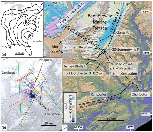
Подтверждение нашлось и на исторических картах: город Саммервилл, расположенный рядом с этим участком, после землетрясения «подрос» на метр. В то же время причалы Форта Дорчестер, находящиеся неподалеку, остались нетронутыми. Это подтверждало гипотезу о мощном движении земной коры вблизи Саммервилла.
Виновник найден: разлом Саммервилл и его роль
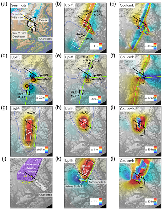
Ученые предположили, что причиной землетрясения стал разлом Саммервилл, проходящий под городом. Эта геологическая структура ранее не рассматривалась в качестве потенциального источника толчков.
Созданная исследователями компьютерная модель показала, что движение по разлому Саммервилл с учетом его западного падения может объяснить как смещение рельсов, так и поднятие рельефа. Расчетная магнитуда события составила 7,3, что соответствует площади распространения сейсмических волн и свидетельствам очевидцев.
Деформация рельсов как сейсмограф прошлого
Но и на этом открытия не закончились. Билхэма заинтересовала причина сильных деформаций рельсов на расстоянии более 30 километров от Саммервилла. Анализ фотографий, сделанных после землетрясения, привел к очередному открытию: изгибы рельсов фактически записали динамику распространения сейсмических волн.
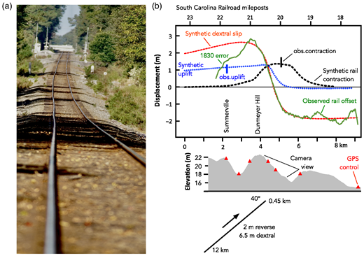
Эта информация оказалась бесценной для понимания характеристик землетрясения и уточнения его магнитуды. Результаты исследований были опубликованы в 2023-2024 годах в журналах The Seismic Record и Bulletin of the Seismological Society of America.
Уроки Чарльстонского землетрясения
Работа Хоф и Билхэма демонстрирует, что даже спустя более 130 лет после события ученые могут делать новые открытия, используя архивные материалы и современные технологии.
Исследование Чарльстонского землетрясения имеет важное значение для понимания сейсмической опасности внутриплитных регионов, где землетрясения происходят реже, но от этого не менее опасны.
Главный вывод работы заключается в том, что исследование прошлого — это не только удовлетворение научного интереса, но и важнейший инструмент прогнозирования будущего и снижения рисков для населения.
В чем парадокс Чарльстонского землетрясения с точки зрения исторической перспективы и развития сейсмологии?
Казалось бы, землетрясение, произошедшее в 1886 году, должно было быть хорошо задокументировано. Однако отсутствие на тот момент глубокого понимания тектонических процессов и сейсмографов для записи колебаний земли сделали это событие во многом загадочным. Ученым пришлось превратиться в детективов, чтобы по крупицам восстановить картину произошедшего.
Почему смещение железнодорожных путей оказалось важнее записей о разрушениях зданий для понимания Чарльстонского землетрясения?
Записи о разрушениях зданий, несомненно, важны для оценки силы землетрясения. Однако, они не дают точной картины движения земной коры. Смещение же рельсов, как линейного объекта, стало наглядным и измеримым свидетельством горизонтальной деформации, указывая на характер и направление движения по разлому.
Можем ли мы считать, что разлом Саммервилл — единственный виновник Чарльстонского землетрясения? Какие еще факторы могли повлиять на характер разрушений?
Хотя разлом Саммервилл и был основным источником землетрясения, на характер разрушений влияют и другие факторы, такие как:
- Тип грунта: Разжижение грунта, наблюдавшееся в Чарльстоне, значительно усиливает сейсмические воздействия.
- Глубина залегания разлома: Более глубокие разломы вызывают менее интенсивные, но более продолжительные колебания.
- Рельеф местности: Холмы и склоны могут как усиливать, так и ослаблять сейсмические волны.
Какое значение имеет исследование Чарльстонского землетрясения для нас сегодня, спустя более ста лет?
Чарльстонское землетрясение напоминает нам, что даже регионы, традиционно считающиеся сейсмически безопасными, могут подвергаться разрушительным землетрясениям. Опыт изучения этого события показывает, насколько важно:
- Вести детальные наблюдения и хранить исторические данные.
- Развивать технологии и модели для анализа сейсмических событий.
- Учитывать сейсмическую опасность при планировании городов и проектировании здан